Background on the Landscape
The landforms of the Village consist of two main glacial outwash terraces that were later cut by the eroding action of the Thomas River on the south and west of the Village.
The soils of the Village consist of early Tertiary sediments including siltstone, sandstone, conglomerate, and high country yellow brown earths, overlain in places by deposits of glacial outwash. The two soil types covering the area of the Village are the “Cass” and “Craigeburn” types . These soils would have originally covered the Village at depth of between 300 mm – 600 mm over gravels. This group of soils are friable, porous, low in clay and sandy in texture. These soils were modified during the initial construction of roads and section formation in the Village in the early 1980s.
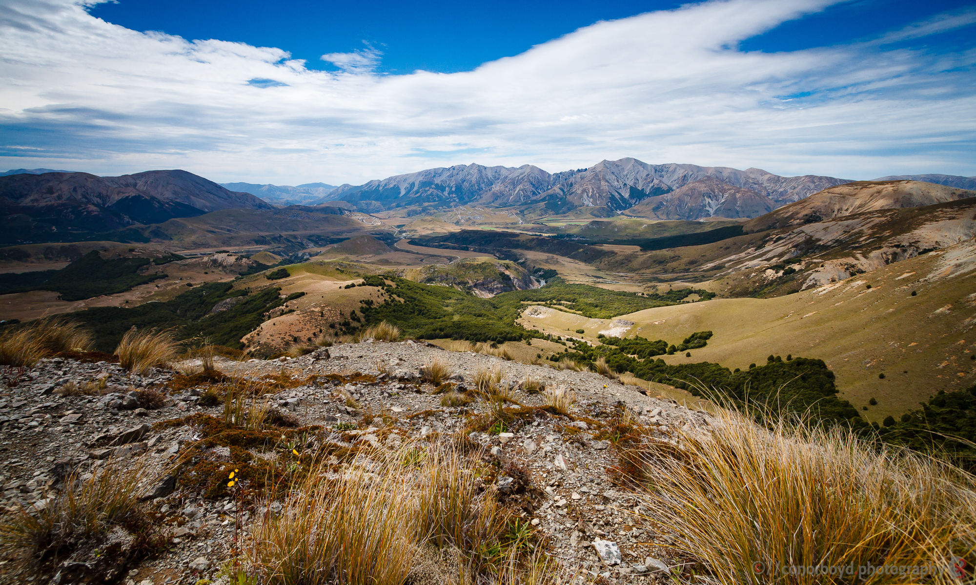
The village is situated within the Upper Waimakariri Basin, an upland area comprising the steep ‘hard rock’ mountains and hills of the Torlesse & Craigieburn Ranges (80%), outwash fans and terraces (15%), and ‘soft rock’ limestone hills and features (5%). Hayward & Boffa refer to it as perhaps the best documented mountain area in the South Island.* They also note the limestone areas in particular have been a focus of scientific and recreational attention, despite their comprising such a small proportion of the land.
Hayward & Boffa’s following description of the Basin is an apt statement of the context surrounding Castle Hill Village: “It is a region of steep mountains, sprawling fans, smooth terraces and wide river beds. It is an area of contrasts: of rain forests and impoverished grasslands, of spectacular erosion and green paddocks, of pleasant hillside streams and raging mountain torrents.”
Human Intervention
The Village is close to the limestone formations, reserves, conservation area and Statutory Acknowledgement Area of Castle Hill/Kura Tāwhiti. Archaeological, traditional and published records indicate the area was important from the Waitaha to the Ngāi Tahu Maori periods. A memorial in Cathedral Square, Christchurch states that Canterbury was occupied from about 850AD until 1505 by the Hawea/Rapuwai/Waitaha confederation, from 1505-1675 by Ngati Mamoe and from 1675-1837 by Ngāi Tahu. These dates are likely also to apply to Castle Hill also, with small variations.
Waitaha
Histories indicate that in Waitaha times the Castle Hill area was called ‘te Kohanga’ or ‘birthplace of the Gods’ and was of astronomical prominence as a key ‘observatory’ for predicting the coming seasons and weather. In summer a considerable population migrated from the coast and supported this role, tending kumara, the sacred vegetable. The limestone geology also was sacred due to the eons of creatures whose remains had built up the rock since the beginnings of time, and who were seen as ancestors. Prominent leaders were buried here, including Rakaihautu, the ancestor who first explored and occupied the South Island about 850AD.
Ngāi Tahu
The Ngāi Tahu name “Kura Tāwhiti” means “the treasure from a distant land”, referring to the kumara vegetable which was once cultivated in this region. Kura Tāwhiti was one of the mountains claimed by the Ngāi Tahu ancestor, Tane Tiki, for his daughter Hine Mihi. Tane Tiki wanted the feathers from the kākāpō taken from this area to make a cloak for her. The area was used by Ngāi Tahu for mahinga kai. The main food collected was the kiore (Polynesian rat) and others included tuna (eel), kākāpo, weka, kiwi, kākā and kererū. Kura Tāwhiti was within a network of trails used for seasonal journeys and access to gathering kai whilst camping overnight. Knowledge of these trails is held by whānau and hapū and is regarded as taonga. Expeditions were also undertaken for other purposes, such as Ahikāroa – keeping cooking fires burning on the land; Mātauranga – handing down knowledge of practices and methods; Kōrero pūrākau – telling the associated traditional stories; Hïkoi rohe – passing on familiarity with tribal and hapū trails and boundaries. The ancient rock art remnants found on rock outcrops are particular taonga of Kura Tāwhiti. The outcrops provided shelter for Ngāi Tahu on their travels and they recorded their beliefs and aspects of their lives here. Not surprisingly, these rock outcrops have tapu status for Ngāi Tahu. In 1998 an area at Castle Hill reserves was designated as Topuni under the Ngai Tahu Claims Settlement Act, to ensure that the values Ngāi Tahu place on this area are recognised, acknowledged and respected.
European
In 1857 the first Europeans, Joseph Pearson and John Sidebottom, explored the Upper Waimakariri Basin, travelling up the Waimakariri River Gorge. Soon after, the grazing runs of Craigieburn, Grasmere and Mt White were leased. The Castle Hill run was the last to be leased, in 1858, by brothers Alfred and Joseph Porter, who had a property, Otarama (now Brooksdale), on the plains side of the mountains. The first bridle track over Porter’s Pass was made in 1858-59. In the Castle Hill vicinity this followed the east side of the Porter River and did not directly pass today’s village site. Castle Hill and Craigieburn stations remained isolated outposts until 1865, when a coach road named the Bealey Road was constructed to the West Coast via Arthurs Pass, accessing the West Coast goldfields. This road passed along the eastern boundary of the Village on the same route as the current State Highway 73. In 1866 the first Cobb & Co stage coaches travelled to Hokitika. Alfred Porter ran sheep on the Castle Hill land, but he lived at Otarama, and brother Joseph stayed in Christchurch working as a lawyer. They built a shepherd’s hut on the present-day Porter skifield access road, but never lived there. John and Charles Enys took over Castle Hill and Otarama in 1864, and in 1865 built a homestead called Trelissick on twenty acres north of the present Village. After Charles died in 1891, John returned to Cornwall. The Trelissick buildings were removed or demolished about 1919. The Brittan family built today’s bach in 1949 and are still the owners. By October 1865, Michael D’Arcy was operating a store with accommodation immediately opposite the entrance to today’s village. In 1871 a new accommodation house was built on the site and in 1887 W J Cloudesley added a new two storey building to the hotel. The coal supply for the hotel came from seams close by on Thomas River banks. In 1903 the Castle Hill Hotel had twenty rooms and had become a popular place for visitors wanting a holiday with plenty of scenery and fresh air, huge log fires and Mrs Cloudesley’s famous scones. The stone for the hotel came from blocks 2km from the site and assembled by a stonemason named Davies. The hotel was gutted by fire in September 1904, and was never re-established, as the coaches had stopped travelling on the road.
The current Castle Hill Village
The land now comprising Castle Hill Village remained farmland from the 1860’s until the 1970’s. The Village was developed in concept in 1971 by John Reid / Castle Hill Developments Ltd. Following initial hearings (where the application for the village was initially declined) the Tussock Grasslands and Mountain Lands Institute prepared a report recommending the current site as the most suitable for a village. Hearings were again held in 1979, with final approval being given in 1980. Stages 1 and 2 of the Village, containing 130 sections, were completed in 1984. The first houses in the Village were occupied in 1985. The 1979 approval hearings contained extensive data relating to the planning and landscape development of the Village and its reserves. Important features of the Village were:
- The Village was designed as a development to accommodate up to 1,400 persons overnight (400 houses and other accommodation units);
- The “overall landscape design concept will be based on identifiable clusters of housing set amongst open space defined principally by trees, drifts of shrubs and grassland”;
- It was recognised that individual sections would be small, but this would be balanced by generous space provisions through the large reserve areas;
- “Tree planting throughout the residential area will have a larch/ pine/ beech theme and it is envisaged that a dense forest-like intermix of the three species will be planted throughout the accommodation and reserve area. Houses roads and access ways will be cut out of the base plantings as and when required.”
- “No tree shall be topped in any circumstances, and no tree otherwise damaged or removed unless absolutely essential. Where it is essential to remove a tree it shall be replaced by one or more trees in the approximate area”;
- “All services shall be reticulated underground for service and storm safety reasons”.
Press Coverage of Village Development
Some interesting/amusing snippets over the years.